


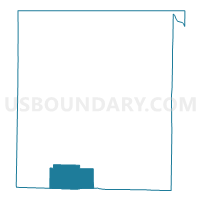
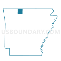
Gaither Voting District, Boone County, Arkansas
About
Outline

Summary
| Unique Area Identifier | 526012 |
| Name | Gaither Voting District |
| County | Boone County |
| State | Arkansas |
| Area (square miles) | 20.99 |
| Land Area (square miles) | 20.97 |
| Water Area (square miles) | 0.01 |
| % of Land Area | 99.93 |
| % of Water Area | 0.07 |
| Latitude of the Internal Point | 36.14799270 |
| Longtitude of the Internal Point | -93.15768990 |
Maps

Graphs
Select a template below for downloading or customizing gragh for Gaither Voting District, Boone County, Arkansas


Neighbors
Neighoring Voting District (by Name) Neighboring Voting District on the Map
- Dogpatch Voting District, Newton County, AR
- Ewing Voting District, Boone County, AR
- South Harrison Voting District, Boone County, AR
- Summit Voting District, Boone County, AR
Top 10 Neighboring County Subdivision (by Population) Neighboring County Subdivision on the Map
- South Harrison township, Boone County, AR (7,590)
- Marble Falls township, Newton County, AR (932)
- Gaither township, Boone County, AR (676)
- Summit township, Boone County, AR (556)
- Ewing township, Boone County, AR (458)
Top 10 Neighboring Unified School District (by Population) Neighboring Unified School District on the Map
- Harrison School District, AR (21,103)
- Jasper School District, AR (5,912)
- Valley Springs School District, AR (4,243)
Top 10 Neighboring State Legislative District Lower Chamber (by Population) Neighboring State Legislative District Lower Chamber on the Map
- State House District 85, AR (29,806)
- State House District 91, AR (29,747)
- State House District 90, AR (29,000)
Top 10 Neighboring State Legislative District Upper Chamber (by Population) Neighboring State Legislative District Upper Chamber on the Map
Top 10 Neighboring 111th Congressional District (by Population) Neighboring 111th Congressional District on the Map
Top 10 Neighboring Census Tract (by Population) Neighboring Census Tract on the Map
- Census Tract 7904, Boone County, AR (6,019)
- Census Tract 7903, Boone County, AR (5,348)
- Census Tract 1801, Newton County, AR (4,077)